Greetings,
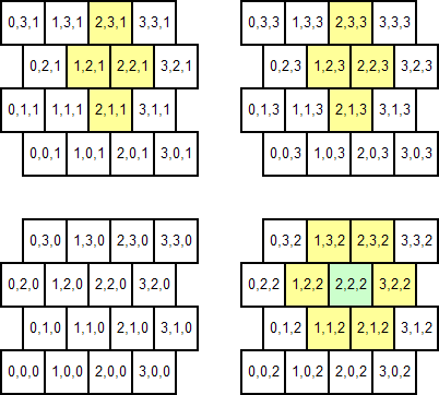
I'm working on a game project that uses a 3D variant of hexagonal tile maps. Tiles are actually cubes, not hexes, but are laid out just like hexes (because a square can be turned to a cube to extrapolate from 2D to 3D, but there is no 3D version of a hex). Rather than a verbose description, here goes an example of a 4x4x4 map:

(I have highlighted an arbitrary tile (green) and its adjacent tiles (yellow) to help describe how the whole thing is supposed to work; but the adjacency functions are not the issue, that's already solved.)
I have a struct type to represent tiles, and maps are represented as a 3D array of tiles (wrapped in a Map class to add some utility methods, but that's not very relevant).
Each tile is supposed to represent a perfectly cubic space, and they are all exactly the same size. Also, the offset between adjacent "rows" is exactly half the size of a tile.
That's enough context; my question is:
Given the coordinates of two points A and B, how can I generate a list of the tiles (or, rather, their coordinates) that a straight line between A and B would cross?
That would later be used for a variety of purposes, such as determining Line-of-sight, charge path legality, and so on.
BTW, this may be useful: my maps use the (0,0,0) as a reference position. The 'jagging' of the map can be defined as offsetting each tile ((y+z) mod 2) * tileSize/2.0 to the right from the position it'd have on a "sane" cartesian system. For the non-jagged rows, that yields 0; for rows where (y+z) mod 2 is 1, it yields 0.5 tiles.
I'm working on C#4 targeting the .Net Framework 4.0; but I don't really need specific code, just the algorithm to solve the weird geometric/mathematical problem. I have been trying for several days to solve this at no avail; and trying to draw the whole thing on paper to "visualize" it didn't help either :( .
Thanks in advance for any answer
Until one of the clever SOers turns up, here's my dumb solution. I'll explain it in 2D 'cos that makes it easier to explain, but it will generalise to 3D easily enough. I think any attempt to try to work this entirely in cell index space is doomed to failure (though I'll admit it's just what I think and I look forward to being proved wrong).
So you need to define a function to map from cartesian coordinates to cell indices. This is straightforward, if a little tricky. First, decide whether point(0,0) is the bottom left corner of cell(0,0) or the centre, or some other point. Since it makes the explanations easier, I'll go with bottom-left corner. Observe that any point(x,floor(y)==0) maps to cell(floor(x),0). Indeed, any point(x,even(floor(y))) maps to cell(floor(x),floor(y)).
Here, I invent the boolean function even which returns True if its argument is an even integer. I'll use odd next: any point point(x,odd(floor(y)) maps to cell(floor(x-0.5),floor(y)).
Now you have the basics of the recipe for determining lines-of-sight.
You will also need a function to map from cell(m,n) back to a point in cartesian space. That should be straightforward once you have decided where the origin lies.
Now, unless I've misplaced some brackets, I think you are on your way. You'll need to:
cell(0,0) you position point(0,0); and adjust the function accordingly;Depending on the size of the playing field you could store the cartesian coordinates of the cell boundaries in a lookup table (or other data structure), which would probably speed things up.
Perhaps you can avoid all the complex math if you look at your problem in another way:
I see that you only shift your blocks (alternating) along the first axis by half the blocksize. If you split up your blocks along this axis the above example will become (with shifts) an (9x4x4) simple cartesian coordinate system with regular stacked blocks. Now doing the raytracing becomes much more simple and less error prone.
If you love us? You can donate to us via Paypal or buy me a coffee so we can maintain and grow! Thank you!
Donate Us With