I have a map that is cut up into a number of regions by borders (contours) like countries on a world map. Each region has a certain surface-cover class S (e.g. 0 for water, 0.03 for grass...). The borders are defined by:
This is one example.
0.0300      0.0000           7
2660607.5   6332685.5   2660565.0   6332690.5   2660541.5   6332794.5
2660621.7   6332860.5   2660673.8   6332770.5   2660669.0   6332709.5
2660607.5   6332685.5
I want to make a raster map in which each pixel has the value of S corresponding to the region in which the center of the pixel falls.
Note that the borders represent step changes in S. The various values of S represent discrete classes (e.g. grass or water), and are not values that can be averaged (i.e. no wet grass!).
Also note that not all borders are closed loops like the example above. This is a bit like country borders: e.g. the US-Canada border isn't a closed loop, but rather a line joining up at each end with two other borders: the Canada-ocean and the US-ocean "borders". (Closed-loop borders do exist nevertheless!)
Can anyone point me to an algorithm that can do this? I don't want to reinvent the wheel!
The general case for processing this sort of geometry in vector form can be quite difficult, especially since nothing about the structure you describe requires the geometry to be consistent. However, since you just want to rasterize it, then treating the problem as a Voronoi diagram of line segments can be more robust.
Approximating the Voronoi diagram can be done graphically in OpenGL by drawing each line segment as a pair of quads making a tent shape. The z-buffer is used to make the closest quad take precedence, and thus color the pixel based on whichever line is closest. The difference here is that you will want to color the polygons based on which side of the line they are on, instead of which line they represent. A good paper discussing a similar algorithm is Hoff et al's Fast Computation of Generalized Voronoi Diagrams Using Graphics Hardware
The 3d geometry will look something like this sketch with 3 red/yellow segments and 1 blue/green segment:
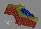
This procedure doesn't require you to convert anything into a closed loop, and doesn't require any fancy geometry libraries. Everything is handled by the z-buffer, and should be fast enough to run in real time on any modern graphics card. A refinement would be to use homogeneous coordinates to make the bases project to infinity.
I implemented this algorithm in a Python script at http://www.pasteall.org/9062/python. One interesting caveat is that using cones to cap the ends of the lines didn't work without distorting the shape of the cone, because the cones representing the end points of the segments were z-fighting. For the sample geometry you provided, the output looks like this:

I'd recommend you to use a geometry algorithm library like CGAL. Especially the second example in the "2D Polygons" page of the reference manual should provide you what you need. You can define each "border" as a polygon and check if certain points are inside the polygons. So basically it would be something like
for every y in raster grid
  for every x in raster grid
    for each defined polygon p
      if point(x,y) is inside polygon p
        pixel[X][Y] = inside_color[p]
I'm not so sure about what to do with the outside_color because the outside regions will overlap, won't they? Anyway, looking at your example, every outside region could be water, so you just could do a final
if pixel[X][Y] still undefined then pixel[X][Y] = water_value
(or as an alternative, set pixel[X][Y] to water_value before iterating through the polygon list)
If you love us? You can donate to us via Paypal or buy me a coffee so we can maintain and grow! Thank you!
Donate Us With